Weer en sneeuw
Weer in Zuid-Tirool
Laatste update: 01.08.2026, 11:00
Het weer vandaag
The air masses are very warm, and the atmosphere remains unstable.
In the afternoon, the sun will once again cause large cumulus clouds to form, leading to a few heat-related thunderstorms. A northerly foehn will pick up in the northern valleys.
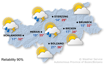
The maximum temperatures are well above average, reaching 27° in Sterzing, where the Föhn is blowing, and 36° in Bolzano.
Het weer morgen
High air pressure and unstable air masses are shaping the weather in South Tyrol.
During the first half of the day, there will be a mix of sunshine and the odd scattered shower. In the afternoon, the cumulus clouds will grow larger and the likelihood of thunderstorms will increase slightly further.
The highest temperatures range from 27° to 34°.
Verdere ontwikkeling

35°/14°
Maandag, 03.08

36°/14°
Dinsdag, 04.08
36°/14°
Woensdag, 05.08
37°/14°
Donderdag, 06.08
On Monday morning, there will be bright sunshine, but a few thunderstorms are likely to develop again in the afternoon.
Tuesday will also bring plenty of sunshine in the morning, after which isolated thunderstorms are expected once again.
Wednesday will bring plenty of sunshine, with the likelihood of thunderstorms rising only slightly in the afternoon.
Thursday will also be sunny, with thunderstorms becoming more frequent in the afternoon.
Bergweer vandaag
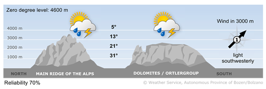
Thunderstorms again this afternoon
After a few hours of sunshine, the cumulus clouds will grow larger and, from the afternoon onwards, we can expect a few heat-related thunderstorms again.
Wind op grote hoogte
1 - zwakke wind
5-15 km/u
2 - matige wind
16-30 km/u
3 - sterke wind
31-60 km/u
Bergweer morgen
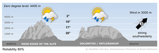
Sunshine and a few thunderstorms
In the early morning and during the morning, clouds may reduce visibility in some areas, and the first thunderstorms are possible. A few heat-related thunderstorms are expected during the afternoon.
Wind op grote hoogte
1 - zwakke wind
5-15 km/u
2 - matige wind
16-30 km/u
3 - sterke wind
31-60 km/u