Weer en sneeuw
Weer in Zuid-Tirool
Laatste update: 08.04.2026, 11:00
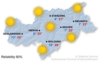
Het weer vandaag
High pressure and warm air masses are set to bring another early summer's day.
It will be very sunny with generally clear skies. The Föhn wind will continue to blow in the northern valleys.
Maximum temperatures between 20° and 28°.
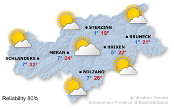
Het weer morgen
Atmospheric pressure will tend to fall and the air masses will become more humid.
It will be mainly sunny. Some high clouds will drift in from the north-west, which may become thicker at times. The Föhn wind will continue to blow in the northern valleys.
Maximum temperatures are from 19°C to 26°C.
Verdere ontwikkeling

23°/-1°
Vrijdag, 10.04

23°/0°
Zaterdag, 11.04

23°/1°
Zondag, 12.04

19°/3°
Maandag, 13.04
A weak cold front will pass through on Friday. Cloud cover will increase, with a chance of a few isolated showers. At the same time, a north wind will begin to blow. Temperatures will fall slightly.
The sun will return on Saturday, but temperatures will be lower.
Sunday will also be very sunny, with a few clouds in the afternoon.
On Monday, conditions will be more changeable with very cloudy skies and a few showers.
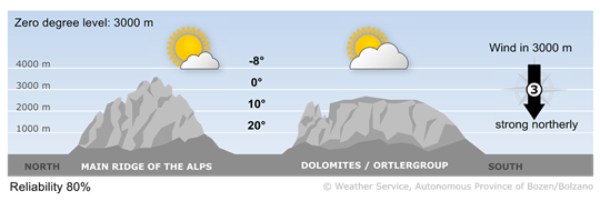
Bergweer vandaag
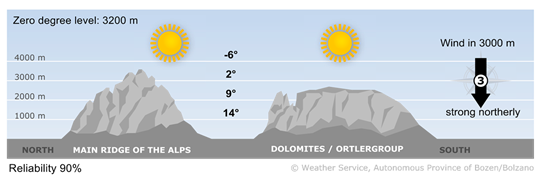
Unclouded sunshine
Another spring day. The freezing level will be above 3,000 m. However, the wind will be quite strong on the peaks.
Wind op grote hoogte
1 - zwakke wind
5-15 km/u
2 - matige wind
16-30 km/u
3 - sterke wind
31-60 km/u
Bergweer morgen
Sun and high clouds
In the mountains of South Tyrol, it will be fairly sunny. Passing high clouds will result in diffused light. It will remain windy.
Wind op grote hoogte
1 - zwakke wind
5-15 km/u
2 - matige wind
16-30 km/u
3 - sterke wind
31-60 km/u